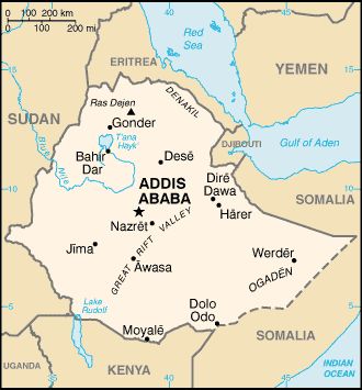
Ethiopia
is located in the Horn of Africa and is bordered on the north and northeast by
Eritrea, on the east by Djibouti and Somalia, on the south by Kenya, and on the
West/Southwest by Sudan.
Elevation and land form: Ethiopia has a high central plateau that varies from 1,800 to
3,000 m (6,000 to 10,000 ft) above sea level, with some mountains reaching (as Ras Degen) 4,620 m (15,158 ft). Elevation is generally highest just
before the point of descent to the Great Rift Valley running generally southwest to northeast and surrounded
by lowlands, steppes, or semi desert. Great terrain diversity determines wide variations in climate,
soils, natural vegetation, and settlement patterns. A number of rivers cross the plateau--notably the Blue Nile rising from
Lake Tana.
Size: About 1,221,900 square kilometers: the major portion of the easternmost African landmass known
as Horn of Africa. It is the seventh-largest country in Africa. The country extends from latitude 3°N to 18°N and longitude 33°E to 48°E,
with approximately equal east-west and north-south dimensions.
 Climate:
Elevation and geographic location produce three climatic zones:
Cool zone: above 2,400 meters where temperatures range from near freezing
to 16° C, 3 temperate zones at elevations of 1,500 to 2,400 meters with temperatures from 16° C to
30, and Hot zone: below 1,500 meters with both tropical and arid conditions and daytime temperatures ranging from 27° C to 50°
C.
Climate:
Elevation and geographic location produce three climatic zones:
Cool zone: above 2,400 meters where temperatures range from near freezing
to 16° C, 3 temperate zones at elevations of 1,500 to 2,400 meters with temperatures from 16° C to
30, and Hot zone: below 1,500 meters with both tropical and arid conditions and daytime temperatures ranging from 27° C to 50°
C.
Normal rainy season (Meher) from mid-June to mid-September (longer in the southern highlands)proceeded
by intermittent showers or small rainy season (belg rain) from February –
April. The remainder of year is generally the dry season (known as Bega).
At Addis Ababa, the Capital city of Ethiopia which is at elevation ranging from 2,200 to 2,600 m (7,000 to 8,500 ft),
the maximum temperature is 26 °C (80 °F) and the minimum is 4 °C (40 °F).
Natural Resources: Agriculture - products: cereals, pulses, coffee, oilseed, sugarcane,
potatoes. Also hides, cattle, sheep, goats, horse, and donkeys.